When the flood came at night – July 14, 2021
A few years ago I went to the annual autumn meeting of the American Geophysical Union in San Francisco and met a Hawaiian geologist who was interested in the geology of the planets, particularly Mars. With a common interest in measuring gas fluxes with infrared gas analysers, she from volcanic rock fissures and I from plant leaf surfaces, we became curious about what motivated us to choose our fields of study. At one point she mentioned that one of her courses had been about the Eifel in Germany. I was amazed. How is it possible that a university course in Hawaii, which is a very interesting geological place, chooses a region some 12,000 km away to learn the principles of earth geology? She replied that the diversity and complexity of the geological formations in the Eifel are so rich that it is particularly suitable for this purpose.
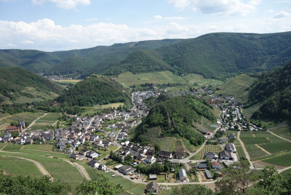
Forming a triangle between Aachen in the north, Koblenz in the east and Trier in the south, the Eifel covers an area of about 5300 square kilometres. It is a hilly region shaped by peneplain erosion and volcanism. The Hohe Acht is the highest hill at 750 m. Average hill heights in the central Eifel are around 500 m and valley bottoms around 200 m. It lies in a temperate Atlantic climate zone with average rainfall of 700 mm/year. It has a rich cultural history dating back to 40,000 years ago when Neanderthals lived in caves. Shaped by its unique morphology, the Eifel has numerous streams, rivers and lakes. The Ahr is one of them. It rises at Blankenheim in the central Eifel at an altitude of 470 metres and flows eastwards into the Rhine at Sinzig, 50 metres above sea level, 85 kilometres away. It is a fast river with small and steep catchments dominated by shale rocks, which prevent the water from penetrating into deeper layers. The picture below shows a meandering section at Mayschoß, famous for its wine production. The river is barely visible and runs between two hills in the foreground. It makes a sharp turn around the left hill before flowing into the neighbouring valley. Such morphological features make villages along the Ahr vulnerable to flood damage.
Meteorological observations of a large trough formation over Central Europe suggested an extreme rain event in the Ahr region for 14 July 2021. Soils were soaked from previous rainfall and could not absorb any more water. The warnings issued earlier in the week were confirmed in the afternoon, when the rain intensified and the gauges on the Ahr river reported sharp rises in water levels far above their normal ranges. At 6pm I started monitoring the Altenahr gauge on a dedicated website. The water level was about 300 cm, 230 cm above normal, and rising fast. It was obvious that something serious was about to happen. The gauge stopped recording at 20:45 when the water level reached 575 cm. A statistical function was continuously applied to the gauge data up to that point, predicting a maximum level of 700 cm for 5pm the next morning. Someone operating the website later replaced the fitted curve with a deterministic model which simulated a peak level of 575 cm for 1 pm the next morning, 125 cm less and 4 hours earlier than the fitted function had predicted. It turned out that discharge data from Müsch, 30 km upstream, suggested that the actual peak could have been 700 cm, as the statistical function had predicted. The model prediction was clearly wrong. This and many other examples show that the calibration of deterministic models of natural processes is severely limited by the dynamics of nature, which cannot always be predicted. As the Hawaiian colleague pointed out, geological processes have shaped the Eifel into a complex terrain. Predicting non-linear fluid dynamics on its highly heterogeneous land surface is a major challenge. Substantial efforts in basic and applied research are needed to make flood forecasts for the Ahr more reliable.
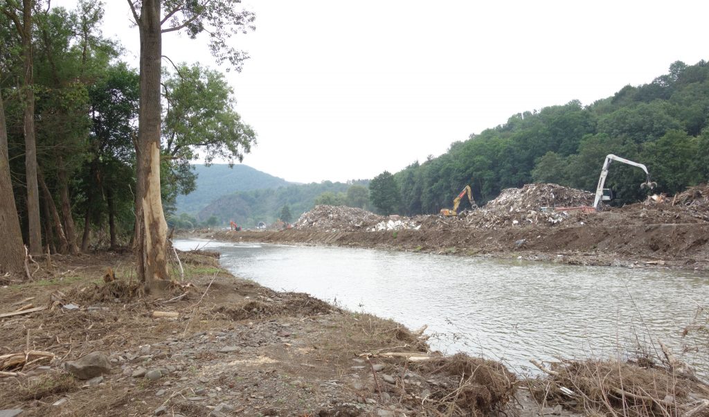
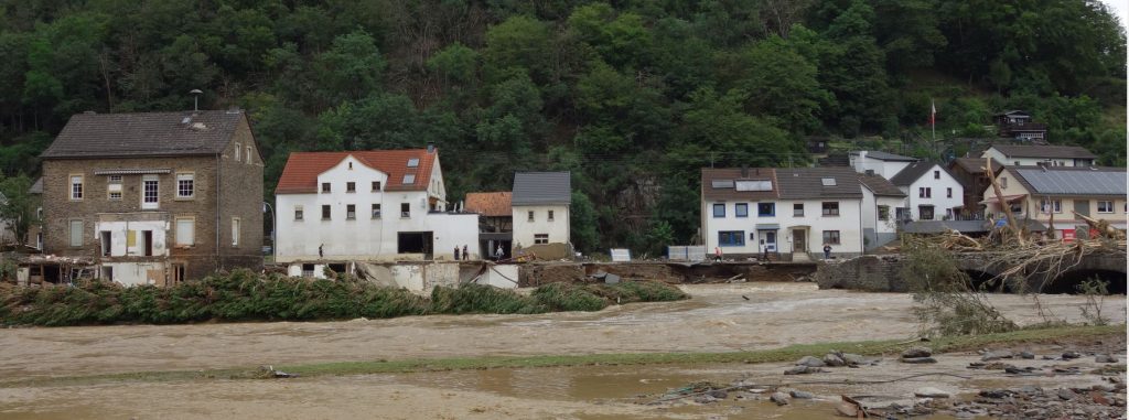
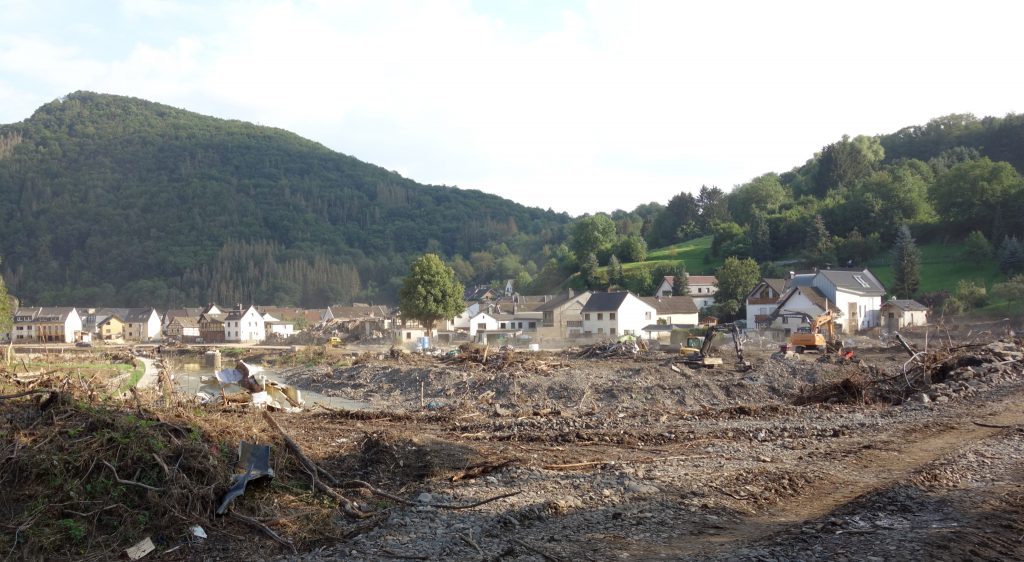
Investigations into the likely course of the Ahr flood on 14 July 2021 have only just begun and will take some time. Weather forecasts predicted rainfall of between 100 and 150 mm/day for the Ahr region, possibly 200 mm/day in isolated places, which eventually came true. The rain continued at high intensity throughout the day until around 22:00. What happened during the following night can only be reconstructed from eyewitness accounts. Extreme water towers in the upper catchment area drained into the Ahr, creating a substantial flood wave. Bales of hay stored in meadows along the river were swept away and blocked bridges. As a result, floodwaters accumulated in front of the bridges until they were destroyed by the increasing water pressure, releasing large amounts of water onto the following bridges, where the same happened again in a chain reaction. Trees planted along the Ahr collapsed into the water due to the rapid build-up of kinetic energy, which intensified its impact on any obstacle in its path. Two tributaries released additional volumes of water into the meandering wave laden with trees and debris before it hit the small towns of Schuld and Insul, causing extreme destruction that was reported on every news channel around the world. The wave came so fast that people had little time to save themselves. Electricity was suddenly cut off, leaving them in the dark. Enormous amounts of water poured into their homes. Many narrowly escaped drowning and made it to higher floors or roofs, if their houses did not collapse under the force of the river. It continued downstream to the Adenauer Bach, a major tributary, which dumped further extreme amounts of water into the Ahr. Passing Liers and Hönnigen, the wave crashed into the small town of Ahrbrück, destroying its bridge, sweeping away houses and flooding others up to the first floor. It continued on to Kreuzberg, a few kilometres downstream, taking a shortcut and leaving huge amounts of trees, rubble, houses, cars, lorries, caravans and every other imaginable material along the riverbanks, piled up to 10 metres high during the subsequent clean-up operation.
The Sahrbach, another stream, added further extreme amounts of water to the Ahr before it flowed through the small town of Altenburg, which was hit twice by the wave, first as it unleashed its destructive force downstream, and later as it bounced back upstream from a bridge blocked by floodwaters in Altenahr, submerging the entire town. Altenahr was declared a disaster area at midnight, allowing the army to move in and help with heavy machinery, as it later did along the entire Ahr on land and from the air. Once the wave had returned downstream to Altenahr, it flowed with great force through three tunnels in the natural barrier and otherwise made a sharp turn through the picturesque Langfig valley before continuing downstream through a wine-growing area between Mayschoß and Walporzheim. All the villages were badly affected and most of the vineyards were destroyed, a tragedy for the Ahr’s wine culture, which dates back to the 8th century. The wave eventually reached Ahrweiler and Bad-Neuenahr, larger towns on the Rhine, which were also badly affected by the flood.
The morning after the flood seemed surreal. Our village on a hill near the river Ahr was unaffected, except for being cut off from electricity, water, roads and telecommunications. The countryside looked as idyllic as ever. It was almost silent. Only the birds were singing. Almost everyone in our village has relatives along the Ahr. They were in deep shock as they tried in vain to reach their relatives in the Ahr valley, despite the telecommunications network being down. As I have a doctorate in cultural engineering and water management, I felt the need to help document the disaster and decided to go to Ahrbrück, which was severly affected. Large parts of the village were flooded up to the first floor. Pumps, where available, were pumping water out of cellars. People were shoveling huge amounts of mud into the streets and trying to get their houses in order. The brief glances and words we exchanged were very moving. A car had been swept into someone’s front garden some distance from the river. What I then saw near the old bridge over the Ahr was disturbing. It had collapsed under the weight of trees and debris. The houses on the left had been swept away, along with most of their inhabitants. People were walking along the adjacent road, stunned. The only sound was the rushing water of the Ahr.
Walking in deep thought in meadows upstream from Ahrbrück, I noticed plenty of household items and debris. A former train embankment was completely eroded and I had to climb over all kinds of obstacles. There was suddenly a distinctive smell. I thought the unthinkable. Are there corpses in this place? Do they start smelling just a few hours after the disaster? A police helicopter was circulating above me with special cameras. I decided to return to our village. It was later confirmed that bodies, some of them shredded into pieces, were found in this and many other places along the Ahr. The largest numbers were found in Bad-Neuenahr and Altenahr. Corpse detection dogs and forensic analyses were used to identify the bodies, as far as this was possible. Few people will be missed forever.
In the days following the flood, emotional discussions ensued, wild opinions were expressed and there was a fierce search for those who might be to blame for the disaster. Some of the arguments were appalling. I felt they were expressions of helplessness and fear. Is there any point in looking for someone to blame in a situation of natural disaster? Three weeks after the flood, it became clear that it would have happened regardless of any human influence. Many claim that the extreme weather event that caused this flood is the result of human-induced climate change. This is only partly true. Geographers at the University of Bonn found that there was a similar Ahr flood in 1804, long before industrialisation, and another in 1910.
Nevertheless, there are a number of human influences that could reduce the scale of such disasters if they were to recur. Renaturation of the Ahr floodplains and construction of flood dams are useful measures. Replacing spruce forests with broadleaved forests and undergrowth would increase the water retention capacity of catchment areas. These have already been damaged by severe drought and bark beetle infestation in recent years. Rethinking agricultural land use to increase water retention capacity could be another measure. Hydrological mistakes made in the 1970s during land consolidation in vineyards need to be reversed. Integrated hydrological catchment management would provide further options for flood control. Collapsing trees in the flood wave were a major source of destructive energy to houses and infrastructure. Tree planting along the Ahr should therefore be discouraged. Campsites, which caused a significant number of deaths, should be located at a reasonable distance from the river and prepared for possible flooding. Those who built their houses too close to the Ahr or in flood-prone areas were severely affected by the flood. Rural and urban development policies need to be adjusted to avoid such dramas. Meteorological and hydrological forecasting needs to be improved to provide more accurate flash flood warnings. Coordination problems in disaster management have been identified and need to be addressed. The discussions on the Ahr flood of 14 July were highly politicised across the political spectrum. Improving the links between environmental science and policy could potentially lead to more informed and responsible decisions on the management of the Ahr catchment and river basin. Short-term projects are not suitable for this purpose. Long-term cooperation in an institutional framework is required.
Something wonderful happened in the aftermath of the flood: a huge wave of solidarity emerged within the Ahr community and quickly spread throughout Germany and beyond. It should serve as a model for future disaster management.
“It is not nature that humans cannot command, but themselves, in all their insignificance and world-altering might” The Economist, July 24, 2021